Vacation / Travel Supplement
Lake Michigan’s Manitou Islands: Indian legend adds to mystery of unique hiking experience

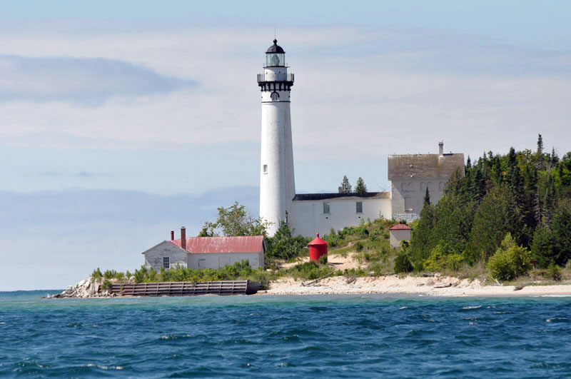
The lighthouse on South Manitou Island is visible across the choppy water of Lake Michigan. Scenic hiking trails on the eight-square-mile south island lead to the lighthouse, as well as a shipwreck, grove of giant cedars and high dune bluffs. (Photo by Mary Ann Garber) Click for a larger version.
By Mary Ann Garber
SOUTH MANITOU ISLAND—As far as the eye can see, the choppy waves of Lake Michigan blend with the brilliant blue skyline in every direction.
The summer sun shines brightly on the hot, sandy beaches dotted with driftwood, sparkles on the water and casts shadows along the wooded pathways that crisscross South Manitou Island.
High above the scenic shoreline, tourists fill the circular deck of the historic lighthouse and look out at the Great Lake which separates Michigan and Wisconsin.
Then their gazes shift to the curving landscape that stretches out around them and resolutely defines the resilience of this eight-square-mile mass of earth and rock—a mere 5,280 acres—in the midst of so much water.
How did this island—and the more desolate North Manitou Island a few miles away—somehow rise above the surface of mighty Lake Michigan, they wonder, then defy the relentless ravages of wind and water for millions of years?
And how did the islands become populated with wildlife like foxes, rabbits, chipmunks and snakes?
Also perplexing, why did the former settlers choose to farm there and withstand the bitter winters for several generations then eventually decide to give up their quiet lifestyle on the island in favor of the busyness of the mainland?
Perhaps even more surprising, how did the Indians find the islands in the first place hundreds of years ago with only canoes for transportation?
A well-known Algonquin Indian legend claims that a mother bear and her two cubs were forced to flee a forest fire in what is now Wisconsin so they swam across Lake Michigan in search of a safer home.
When the mother bear reached the Michigan shore, she climbed a steep bluff to wait for her babies, according to the folklore. But the waves were too large for the exhausted cubs and the shore was too far away. They drowned not far from land. Grief-stricken, the mother bear continued her lonely vigil until her death.
Where the cubs perished, the Great Spirit Manitou created two islands, the legend explains. Then Manitou marked the mother’s resting place with a huge mound of sand that became known as Sleeping Bear Dune.
Science tells us that massive glaciers formed the two islands, the Straights of Mackinac and dune-covered shorelines about 50,000 years ago, but the Indian legend adds to the mystery and romance of the rugged region.
Now, the bear-shaped dune and the twin islands are popular tourist attractions as part of Sleeping Bear Dunes National Lakeshore in northwestern Michigan.
Ferryboats depart from Leland, Mich., daily during the summer months for the 90-minute cruise to the south island across the Manitou Passage, an international shipping lane in the Great Lake that is guarded by the North Manitou Shoal Light to prevent shipwrecks.
Another lighthouse, built in 1871 to replace earlier warning beacons constructed in 1840 and 1858, rises high above the eastern shore of South Manitou Island.
These lighthouses saved many a ship’s crew from coming too close to the shallow waters around the island over the decades.
But on the cold and stormy night of Nov. 29, 1960, the captain of the Francisco Morazan, a freighter from Liberia, failed to safely navigate past the south island and ran his cargo vessel aground along its southern beach.
All of the crew members were rescued by the U.S. Coast Guard, but the shipwreck still lies rusting offshore more than 50 years later, home only to the birds that happily nest there.
Day visitors and overnight campers love to hike the island’s wooded pathways to take pictures of what is left of the steel freighter off the southern shoreline.
Hikers also enjoy exploring the Coast Guard Station established in 1901, now operated by the National Park Service.
Many tourists also climb the steep winding steps of the lighthouse to get a bird’s-eye view of the island and lake.
Others walk across the island to see the grove of giant virgin white cedars and gaze in awe at the massive North American champion cedar, which measures 17.6 feet in circumference, stands more than 90 feet tall and dates back to before Italian exploreer Christopher Columbus discovered America in 1492 while on an expedition for Spain.
Abandoned farms on the south island are reminders of a time when the German immigrants worked hard to stake out and maintain a livelihood in the wilderness of the northern Midwest even though winters on the islands were brutally cold and the ice cover on Lake Michigan kept them isolated for months.
The settlers built a school and general store on the island, farmed the soil and set aside land for several cemeteries. A succession of lighthouse keepers kept watch for ships passing by and maintained the huge safety beacon at Sandy Point near Crescent Bay.
In 1970, the federal government legally acquired the islands and incorporated them into Sleeping Bear Dunes National Lakeshore to preserve their wilderness beauty.
Key points on a map of the south island are the lighthouse and residence at Sandy Point, boat dock in Crescent Bay, weather station campground, Francisco Morazan shipwreck, Valley of the Giants grove of cedars, huge perched sand dunes on the western shoreline, Florence Lake, and the ruins of four farmhouses and a cabin.
North Manitou Island is about three times larger than the south island and nearly twice as long. It’s also more desolate and has fewer amenities that appeal to many tourists.
Most visitors will prefer hiking the south island, where park rangers are happy to offer information and help during the daily ferry service months of June, July and August. Sightseers will appreciate the park service restrooms near the dock and even the outhouse near the weather station and shipwreck.
There’s just one catch to visiting the scenic south island. The Manitou Island Transit, which operates the ferry from Leland, operates on a very strict time schedule so if hikers miss the last boat ride out for the day they get to stay overnight!
Unless tourists are planning to camp there, the thought of getting left behind on the island certainly adds to the excitement and fun of exploring its amazing, one-of-a-kind sights that make it a memorable vacation destination well worth returning to on another hot summer day. †