Vacation / Travel Supplement
Alaskan cruise:
Incredible views of land and sea captivate tourists
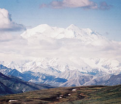
Beautiful views of majestic mountain ranges, like Mount Denali, form a backdrop for vacation destinations in Alaska. Denali National Park is located in the northernmost range of the Rocky Mountains. Mount Denali was formerly named Mount McKinley, and is the highest peak in North America. Its peak is often obscured by mists and clouds. (Submitted photo)
By John F. Fink (Special to The Criterion)
When our friends, Ed and Cynthia Dewes of Bainbridge, vacationed in Alaska, their trip was more extensive than the Alaskan cruise that my wife, Marie, and I enjoyed because they went farther north and inland.
Our cruise was along the part of Alaska that hangs down the west coast of Canada. The northernmost point on our trip was the southern part of the great land mass that people think of when they visualize the state of Alaska.
Nevertheless, our cruise on the Inside Passage from Vancouver to Skagway and back was one of the nicest cruises that we have taken throughout the world.
The weather at the end of August and during the first few days in September couldn’t have been finer, and we were able to take full advantage of the cities where we stopped along the way.
Vancouver, British Columbia, is a wonderful city. Our itinerary included a sight-seeing tour of the city before we boarded our cruise ship, and time to explore the city on our own after we returned. But that’s another story.
Our first stop on the cruise was Ketchikan, a picturesque city of 13,500 people, a bit spread out along the coast but only about two blocks wide. Majestic mountains are visible in the background, with snow on the peaks, but the temperatures in Ketchikan were in the 70s all day.
Since it was a Sunday, our first activity was to find the Catholic church in Ketchikan in time for the 8:30 a.m. Mass. Our cab had to negotiate some very steep hills to get us to Holy Name Church, a modern church with a panoramic view of the mountains through windows in the sanctuary. The gorgeous view was somewhat distracting, though, during the Mass.
Ketchikan is known for its nearby Misty Fiords National Park. A fiord is a long, narrow and often deep inlet from the sea with steep cliffs on both sides. These particular fiords are called “misty” because rain, mist and fog usually shroud them. Ketchikan gets a lot of rain. We were told that there had been only seven days that summer when it didn’t rain.
There was no rain when we were there, though. We flew in a 10-passenger pontoon “bush” plane to the Misty Fiords. We took off from the harbor near our ship, and reached an elevation of about 2,000 to 4,000 feet among the peaks of the mountains and cliffs that rise over 3,000 feet from sea level. We could see how they drop to the water below. It was spectacular!
We flew over three inlets named George, Carrol and Thorne Arm. The Forest Service has built recreation cabins on more than 100 lakes, including Ella Lake and Big Goat Lake.
At Big Goat Lake, which is 1,775 feet above sea level, a waterfall plunges nearly 1,000 feet into Rudyard Bay. The lakes were created by melting glaciers.
Our plane landed on Nooya Lake, which is about 800 feet deep and surrounded by the sheer cliffs. We stood on the plane’s wings, and marveled at the sights and the silence.
On the flight back, the pilot flew for a while at about 50 feet above the water in the various inlets to give us an idea of the way that pilots have to fly there about 80 percent of the time. Because of the usual rain and fog, our pilot said, they have to fly close to the water because they can’t see the cliffs.
Our ship’s next stop was in Juneau, Alaska’s capital. It’s the only state capital that you can’t drive to since it’s on an island and there’s no bridge. Like Ketchikan, it’s spread out along the shore with a huge mountain rising straight up behind the city. The temperature was about 60 when we got up in the morning, but warmed up to about 80 later in the day. We were told that was unusual because high temperatures in the summer are usually 60 to 65.
We took a helicopter flight to Mendenhall Glacier. This massive river of ice moves down the mountain at about two feet a day. We landed on the glacier at about its midway point, where it’s about 300 feet deep, although it has been melting. Unless there is a change in the climate, the glacier will eventually disappear. We walked around in “moon boots” that gave us traction on the ice.
The helicopter flew us to the peak of the glacier, where we could see several tributaries pouring into the main glacier—if you can call moving two feet a day “pouring.”
Skagway is a little village at the north end of the Inside Passage. During the Klondike Gold Rush from 1889 to 1918, it had about 10,000 residents, but today it has only about 700 permanent residents.
During the Gold Rush, the quickest way to get to the Klondike, 600 miles north of Skagway, was by steamer from Seattle to Skagway then over either the Chilkoot or White Pass trails to get over the mountains and then on to Lake Bennett, where the prospectors built boats for a 500-mile journey down the Yukon River to the gold fields. It was grueling, to say the least.
In 1898, work began on a railroad over White Pass, although surveys showed that it couldn’t be done. The completed railroad climbed from sea level in Skagway to 2,865 feet at the summit, with grades as steep as 3.9 percent. Workers had to hang suspended by ropes from vertical granite cliffs, chipping away with picks and planting dynamite to blast through the mountains. With the deaths of “only” 35 men, the track reached the summit on Feb. 18, 1899, and by July 6 of that year construction reached the headwaters of the Yukon River at Lake Bennett.
We rode that railroad in a vintage 1890s parlor car. The track more or less follows the Skagway River, which flows from the summit down to the ocean—all whitewater, of course. As the train climbed along the gray rock cliffs that rise almost straight up, though, the river was well below us.
We went through a tunnel that had been hand drilled and blasted. We went past a steel bridge constructed in 1901, then the tallest cantilever in the world. To say that it was a fascinating ride is an understatement.
After the ride back down, we explored Skagway. It’s seven blocks long and two blocks wide, and it looks like a town right out of the movies. The wood buildings were built during the Gold Rush days. There are wooden plank sidewalks, and horses and carriages are in the streets. There’s an
old-time barber shop, a saloon, an old newspaper office, an old-fashioned looking hotel and other sites from yesteryear.
On our cruise back, we stopped at Wrangell, a small town of 2,300 people near the center of the Alaska Panhandle. It’s named for Baron Ferdinand Petrovich Wrangell, a scientist, explorer and manager of the Russian American Company in the 18th century. Residents boast that it is the only Alaskan town to be under three flags—Russian, British and American. Today, the timber industry is the town’s major employer.
Cruising on the Inside Passage is much more like cruising in a lake than in the ocean. It always appears that you’re surrounded by mountains and trees. The water is smooth like glass because there’s no surf pounding on the shore.
Of course, there were daily lectures about Alaska, its history and its people, including the Eskimos and Tlingit Indians.
I thought the cruise was fantastic even if we didn’t get farther north.
(John F. Fink is a member of St. Luke the Evangelist Parish in Indianapolis and is the editor emeritus of The Criterion.) †